

Kirkwood facts and early settlers
Part of the ‘Smith family history’ series
Part of the ‘Kirkwood history’ series
In the next several posts I’ll be providing background on the Kirkwood neighborhood of Atlanta. Hopefully this will help shed some light on why the Smith family would have moved here from their home on Whitehall, or at least provide some interesting historical context about the place. For any readers not familiar with Kirkwood, I’ll first provide some basic facts and mention some of the early landowners that held property that comprises modern-day Kirkwood.
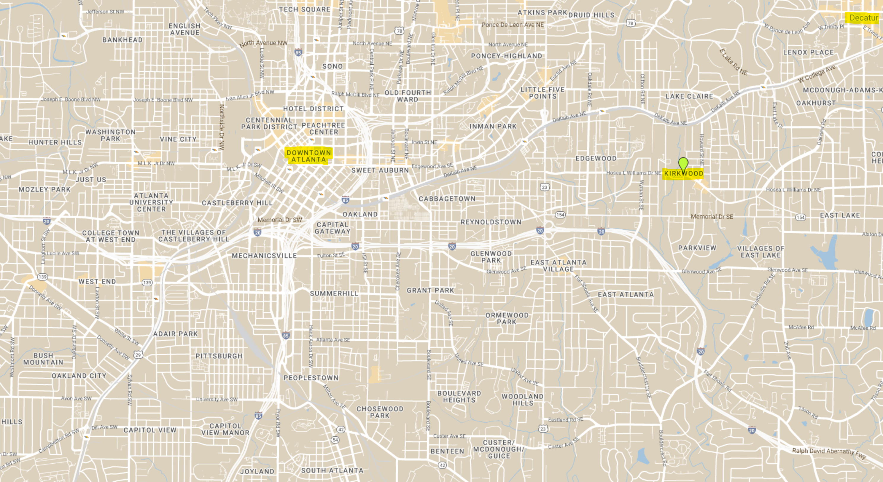
Today, Kirkwood is a neighborhood in the City of Atlanta. Depending on where you measure to and from, Kirkwood is approximately 3.5 – 4 miles from downtown Atlanta and 1.5 – 2 miles to the City of Decatur. The following map shows the general location of Kirkwood in relation to downtown Atlanta and Decatur.
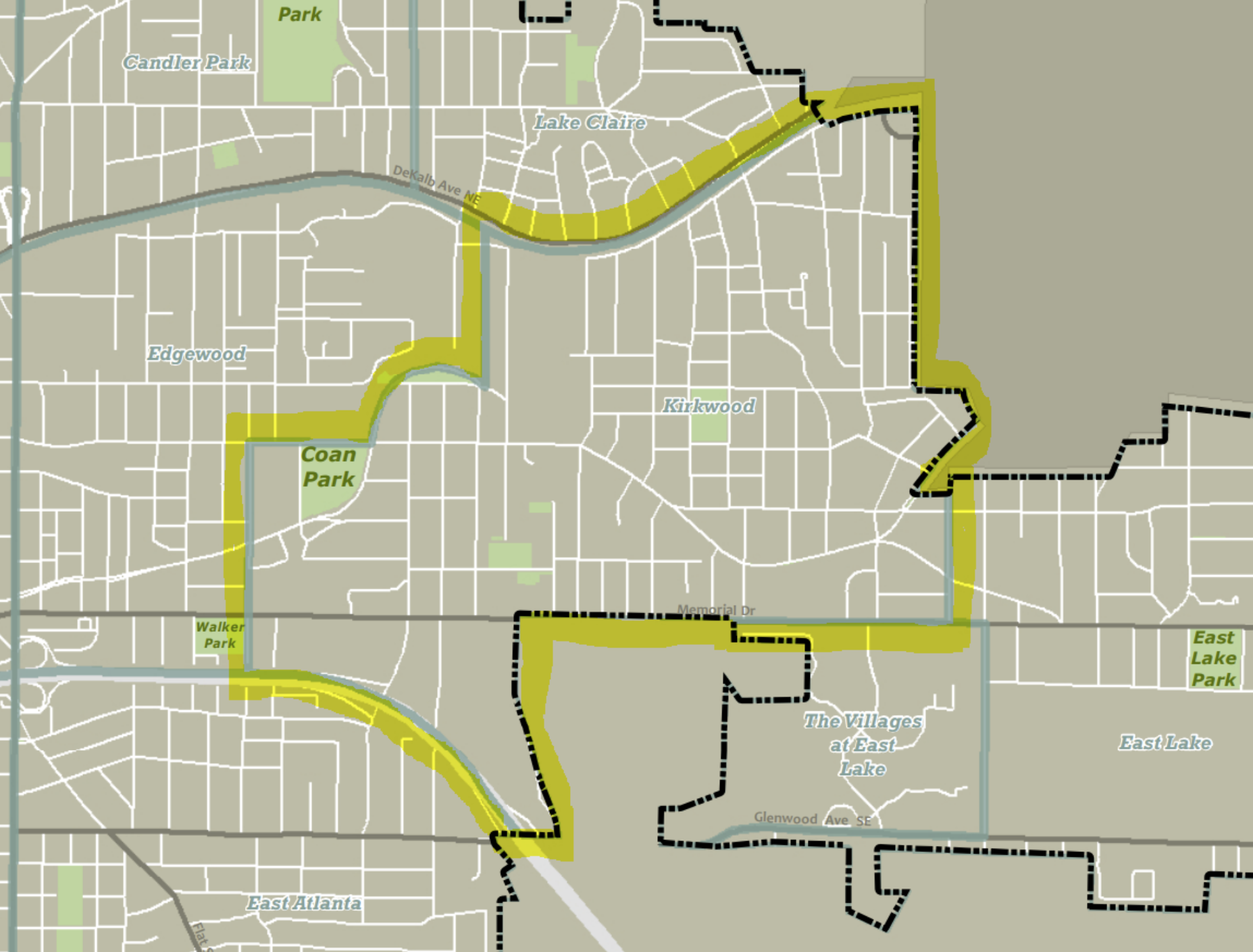
The current Kirkwood boundaries as defined by the City of Atlanta are highlighted on the following map. I believe the Southwest section following Sugar Creek on the south side of Memorial Drive is historically more connected to the Parkview neighborhood. Parkview is within unincorporated DeKalb County, but the western edge includes 21 acre DeKalb Memorial Park, situated within City of Atlanta, but managed by the DeKalb County Department of Recreation, Parks & Cultural Affairs (DRPCA). Note that this area south of Memorial is actually in DeKalb County land lots 178 & 179.
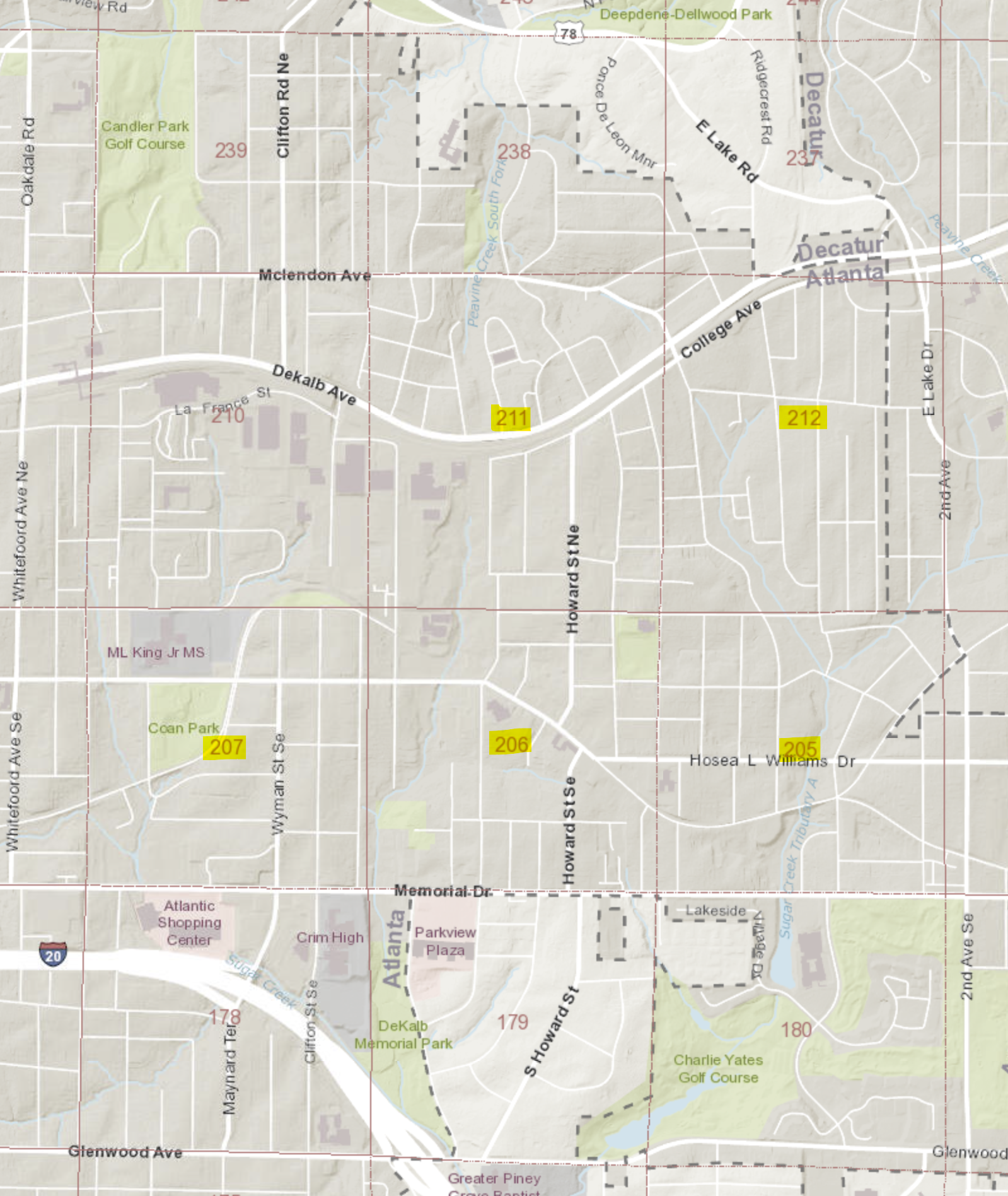
All of Kirkwood is within DeKalb County, Georgia, specifically within district 15, and covering some or all of land lots 205, 206, 207, 211, and 212 (the portion that includes Gilliam Park is located in the SE corner of land lot 210). I’ve highlighted the relevant land lots on the map below.
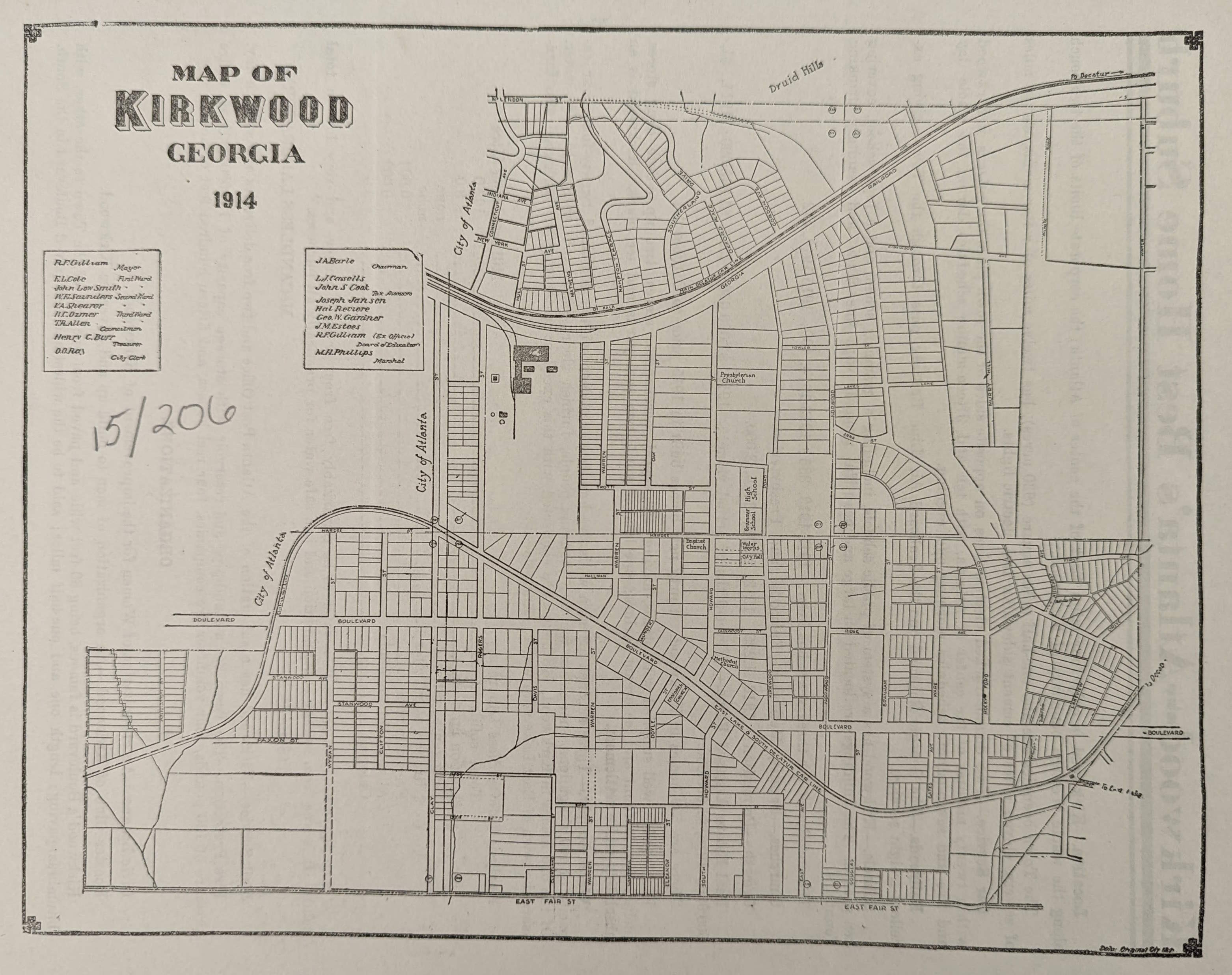
The boundaries of what was historically referred to as Kirkwood were originally somewhat unclear, but we do know that following incorporation and prior to the 1922 annexation into City of Atlanta, the southern part of the current Lake Claire neighborhood, specifically south of McLendon Avenue, was in fact legally part of Kirkwood. The following 1914 map illustrates the boundaries at that time.
Rather than rehashing the significant efforts that were undertaken to register Kirkwood with the National Park Service within the National Register of Historic Places, I would strongly encourage you to read the following document. It includes a useful historical overview of Kirkwood.
As the NRHP document above indicates, Kirkwood, and all of DeKalb County, was originally occupied by the Muscogee (Creek) people. The first Treaty of Indian Springs in 1821 resulted in 4,000,000 acres being ceded to the state of Georgia. DeKalb County was formed the following year. The Georgia Land Lottery Act of 1821 enabled (white) settlers to purchase land lots at the rate of $19 for the given 202.5 acre land lot they were drawn for.
It is unclear whether any of the land lottery winners for the area comprising modern day Kirkwood actually settled here. However, by 1826/1827 two notable landholders had acquired significant tracts of the land.
Jesse Clay Sr. (1792*-1871) purchased some or all of land lots 206 and 207 in 1826 and the land was used for farming. The Clay Cemetery still exists today on Clifton Street. My friend Earl Williamson has done significant research on the Clay family and his efforts to document and preserve the historical integrity of the Clay Cemetery are exemplary. Here are a few links for more information about the Clay family and cemetery.
https://www.facebook.com/ClayCemeteryPreservation
https://dekalbhistory.org/wp-content/uploads/2020/04/clay-cemetery-master-document-mail-size.pdf
https://web.archive.org/web/20220807230838/https://claycemetery.org/2014/08/03/history-of-the-land-belonging-to-the-clay-family/
* Note, that some sources indicate Jesse Clay’s birth year as 1786. However, the 1830, 1840, 1850, and 1860 census records all line up with 1792. The 1870 census indicates his age as 84, which may be the origin of the 1786 date.
James Hutchinson Kirkpatrick (1778-1853) settled in the area around 1827. The following excerpt from Franklin Garrett’s Atlanta and Environs provides a good description of Kirkpatrick.
De Kalb County acquired the progenitor of one of its most prominent families when James Hutchinson Kirkpatrick arrived from Morgan County, Georgia, in 1827. He was also probably the first native-born Irishman to settle permanently in De Kalb. Born in County Antrim in 1778, he was brought to America by his parents at the age of six. Before coming to De Kalb from Morgan, he and his wife, Ann Parks, had lived in Mecklenburg County, North Carolina and Jasper County, Georgia. At the time of his death, in 1853, he owned a thousand acres of land – upon which most of Kirkwood later developed. That community, now a part of the City of Atlanta, was named for the Kirkpatrick family. Aside from his extensive land holdings, James H. Kirkpatrick left a large estate in personal property, one of the largest in De Kalb at that time. Excluding realty and obligations due, but including eleven slaves, the estate was appraised by Ezekiel Mason, Joseph Pitts, Joseph F. Clay and L. S. Morgan at $11,157.00. His children, as named in the will were: Jane, wife of Joseph Morgan, and James W., Thomas M., Hugh P., John L., and William N. Kirkpatrick. Through the years their descendants have been useful citizens of the community.
Franklin M. Garrett. Atlanta & Environs, Volume I. Page 65
In the next post I’ll go a bit deeper to investigate the Kirkpatrick family, the real estate they owned, and more.
